Protected areas
Some of the Northern Territory’s most beautiful national parks are in the Central Land Council’s region.
Australia’s most famous natural icon, Uluru, is on Aboriginal land in the region, as are tourist attractions such as the Karlu Karlu (Devils Marbles) Conservation Reserve and the Tjoritja (West MacDonnell) National Park. Most of these parks and reserves are jointly managed by their Aboriginal traditional owners and government agencies.
The region is home to four indigenous protected areas (IPAs), Aboriginal land where traditional owners receive financial support from the Australian Government to protect ecological and cultural values. Guided by the traditional owners, our rangers manage the Northern Tanami IPA, the Southern Tanami IPA, the Angas Downs IPA and the Katiti–Petermann IPA. We are consulting with traditional owners of the Haasts Bluff Aboriginal Land Trust about declaring our fifth IPA there.
An interactive map of all our protected areas is here
Northern Tanami IPA
Yapa (Warlpiri for Aboriginal people) traditional owners hold 90 per cent of the vast and relatively untouched Tanami region as Aboriginal freehold title. In 2007 they declared some four million hectares of this Aboriginal estate an IPA, a significant addition to Australia’s national reserve system.
The IPA provides sanctuary for a myriad of desert animals and plants. Its sandplains, dunes and many ephemeral wetlands are a haven for threatened species such as the walpajirri (bilby), warrana (great desert skink), jajina (mulgara) and pujarr-pujurrpa (marsupial mole).
The IPA also offers important benefits to the traditional owners of the northern Tanami region. These include increased opportunities to visit and maintain cultural sites and transfer cultural knowledge, while also working alongside the Northern Tanami rangers to manage fire, weeds, feral animals and threatened species. A plan of management and the guidance of senior traditional owners on the IPA management committee direct these activities. Lajamanu residents have used mining compensation income to help fund a Warlpiri language online version of the plan.
Southern Tanami IPA
The Southern Tanami IPA, which encompasses more than 10 million hectares, is the largest terrestrial conservation reserve in Australia. Declared in 2012, it incorporates vast expanses of the Tanami Desert surrounding the communities of Yuendumu, Nyirrpi and Willowra. Most of the IPA’s Yapa traditional owners and rangers live in these remote communities.
The IPA contains two sites of international conservation significance — Lake Mackay and the South West Tanami Desert with its biologically significant ancient drainage system. The IPA features extensive spinifex sandplains, low rocky ranges and the ephemeral Lander River and its associated lakes, swamps and waterholes. These landscapes contain a mosaic of habitats which supports significant populations of endangered species such as bilbies which once ranged over much of the Australian mainland.
Working to a plan of management and guided by traditional owner committees, the Warlpiri Rangers based in Yuendumu, Nyirrpi and Willowra have been monitoring and managing bilby populations and other threatened species across the IPA for more than a decade. The CLC has created a Warlpiri language online version of the management plan to enable traditional owners to fully understand the works being undertaken by their people to protect their country.

Angas Downs IPA
The Angas Downs IPA, approximately 300 kilometres southwest of Alice Springs, is the smallest IPA in our region. Declared in 2009, the 323,000 hectare area contains cultural and environmental values of great importance to its Anangu (Pitjantjatjara Yankunytjatjara speaking) traditional owners who continue to perform ceremonies at significant sites. Many live at the Imanpa community 50 kilometres east of the IPA.
The area has mulga and desert oak woodlands, gypsum depressions, limestone plains, spinifex-covered sand dunes, alluvial floodplains and quartzite hills. Unlike the other IPAs in our region, it is a pastoral lease. The Imanpa Development Association, an Aboriginal organisation, owns the lease.
A management principle is ara nyangaku tjunguni Anangu-ku ara (Tjukurpa / Wapar) munu piran-ku ara wirura malu, kalaya, tinka munu tjulpu tjutaku ngura palyanku atunymankunytjaku, nganampa ngura munu mai ngaranyangka uranma (mixing Anangu customary knowledge and the law with scientific knowledge to improve wildlife habitat, enhance landscapes, and harvest species on a sustainable basis).
Katiti–Petermann IPA
The traditional owners of country surrounding Uluru—Kata Tjuta National Park declared the Katiti–Petermann IPA in 2015. The IPA’s five million hectares of inalienable Aboriginal freehold land links with nine other protected areas in the cross-border region of the Northern Territory, Western Australia and South Australia.
Many songlines or dreaming tracks traverse the area, via numerous culturally significant sites. Its ecologically diverse plant and animal communities include several nationally listed threatened species — the tjakura (great desert skink), murtja (brush-tailed mulgara) and waru (black-footed rock wallaby).
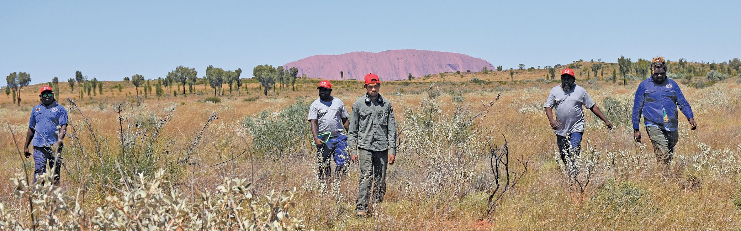
Our ranger groups based at Kaltukatjara (Docker River) and Mutitjulu implement the traditional owners’ cultural and natural resource management priorities as identified in the IPA plan of management.
Led by a traditional owner management committee, these Kaltukatjara and Tjakura rangers conduct plant and animal surveys with scientists using both traditional tracking and contemporary methods. They lead cross-border fire management to reduce the impact and frequency of devastating summer wildfires, manage feral camels and protect important cultural sites where elders teach younger Anangu about the tjukurpa (dreaming).
National Parks
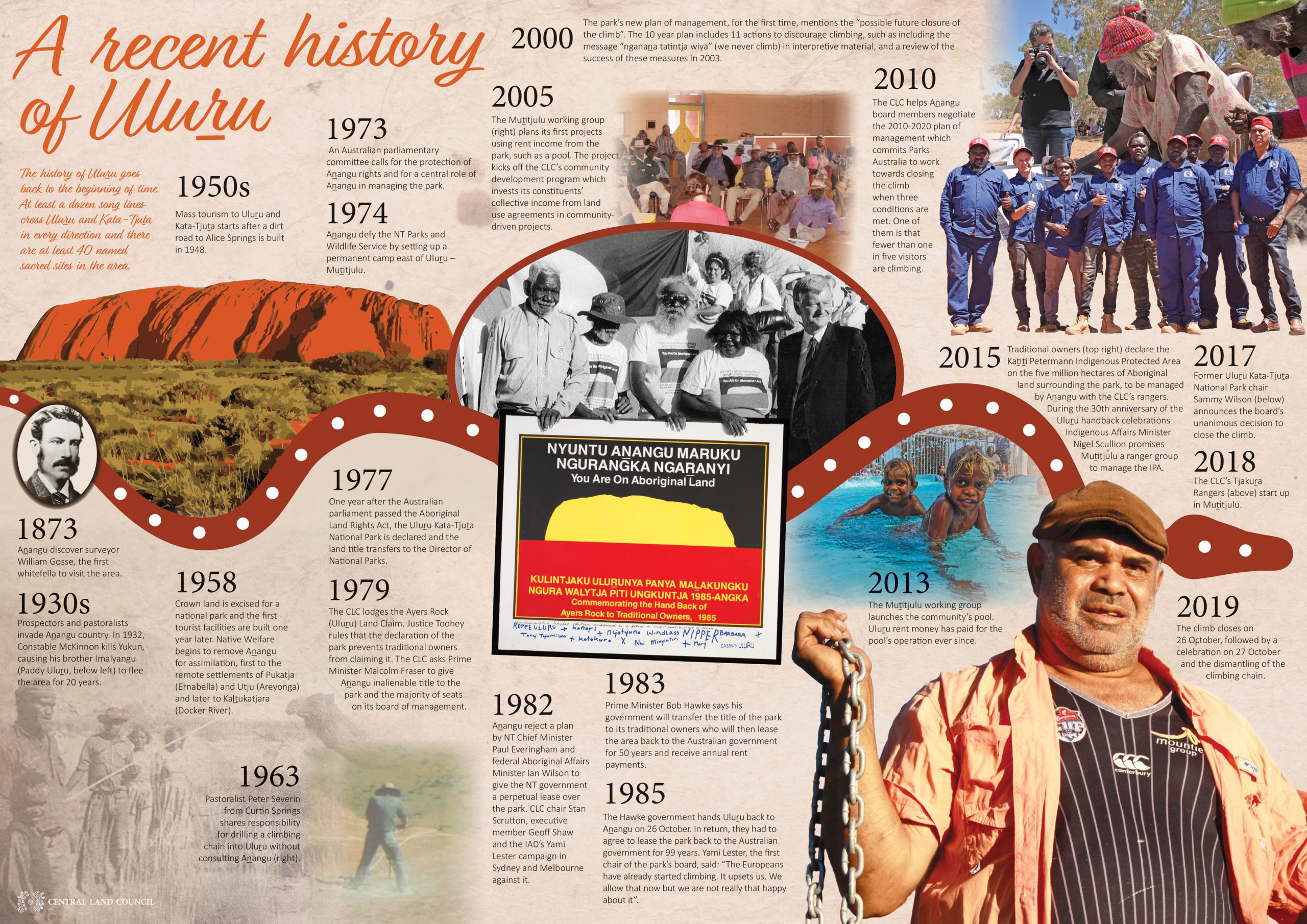
The Uluru – Kata Tjuta National Park inside the Katiti–Petermann IPA has been under joint management by traditional owners and Parks Australia since 1985, when the traditional owners leased the park back to the Australian government for 99 years.
Another 20 parks in our region are now similarly jointly managed by traditional owners and the Northern Territory’s Parks and Wildlife Service (PWS).
The joint management partners combine traditional knowledge and contemporary land management practices to care for the parks. This approach aims to create employment for Aboriginal people and educate PWS staff about Aboriginal land management methods and priorities. It best protects culturally sensitive areas while allowing the wider community to enjoy these 20 parks without entry fees or permits. Increased engagement and employment of Aboriginal people traditionally associated with the parks is expected to transform the identity of each park over time.
The transformation began when the traditional owners increased their leverage and thus voice in the management and care of these parks. In 2005 the Northern Territory government passed the Parks and Reserves (Framework for the Future) Act which settled outstanding land and native title claims affecting 20 NT parks and reserves in the CLC region. Between 2008 and 2012, 16 were returned to their traditional owners and most then leased back to the government for parks for 99 years. The remaining four are subject to joint management under land use agreements registered with the National Native Title Tribunal. The Territory Parks and Wildlife Conservation Act now sets out the principles and objectives of their joint management.
Before a national park can be jointly managed the NT Legislative Assembly must pass a joint management plan. Thirteen of the 20 parks in the CLC’s region have new joint management plans.